![](/images/other/stat-length.png)
![Randonnée Marche La Hague - Biville / Auderville - Photo](https://media.geolcdn.com/t/1900/400/ext.pjpeg?maxdim=2&url=https%3A%2F%2Fstatic1.geolcdn.com%2Fsiteimages%2Fupload%2Ffiles%2F1553511878bg_sport_marche.png)
Biville / Auderville
BernardHumeau
Utilisateur
![Longueur](/images/other/stat-length.png)
Longueur
20 km
![Altitude max](https://static1.geolcdn.com/siteimages/upload/files/1508320355ic_sort_altitude_max_24dp.png)
Altitude max
112 m
![Dénivelé positif](https://static1.geolcdn.com/siteimages/upload/files/1508320355ic_sort_den_pos_24dp.png)
Dénivelé positif
560 m
![Km-Effort](/images/other/stat-length.png)
Km-Effort
28 km
![Altitude min](https://static1.geolcdn.com/siteimages/upload/files/1508320355ic_sort_altitude_min_24dp.png)
Altitude min
3 m
![Dénivelé négatif](https://static1.geolcdn.com/siteimages/upload/files/1508320355ic_sort_den_neg_24dp.png)
Dénivelé négatif
609 m
![Boucle](https://static1.geolcdn.com/siteimages/upload/files/16400158638029165_repeat_loop_refresh_sync_direction_icon.png)
Boucle
Non
Date de création :
2020-03-12 13:26:52.727
Dernière modification :
2020-03-12 13:38:56.047
![Marche](https://static1.geolcdn.com/sitytour/trail-icons/101.png)
5h52
Difficulté : Très difficile
![Scannez ce code QR pour ouvrir la randonnée dans l'application SityTrail](https://capi.geolives.com/qq0zvz2zws4bq2lad0pu/sitytour/trails/2361288/qr.png?size=200)
Application GPS de randonnée GRATUITE
À propos
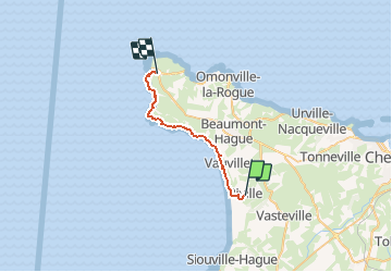
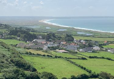
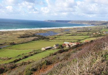
Randonnée Marche de 20 km à découvrir à Normandie, Manche, La Hague. Cette randonnée est proposée par BernardHumeau.
Description
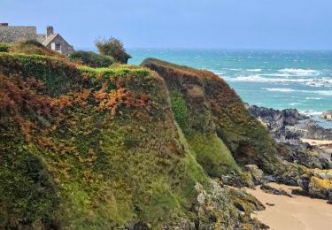
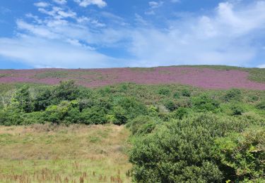
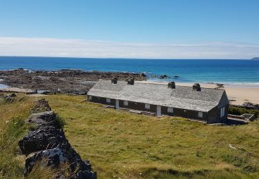
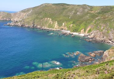
Dernière étape du " Cotentin", tranquille au départ, les difficultés n'apparaissent que dans la 2ème moitié :rochers,falaises,....histoire de garder de bons souvenirs !!!
Localisation
Pays :
France
Région :
Normandie
Département/Province :
Manche
Commune :
La Hague
Localité :
Biville
Départ:(Dec)
Départ:(UTM)
585069 ; 5496126 (30U) N.
Commentaires
Randonnées à proximité
![Randonnée Marche La Hague - Séjour Cotentin Etape 4 Biville - Les Pieux - Photo](https://media.geolcdn.com/t/375/260/20c319c1-9c7e-4f29-bee7-385fa39e6485.jpg&format=jpg&maxdim=2)
![Marche Marche](https://static1.geolcdn.com/sitytour/trail-icons/101.png)
Séjour Cotentin Etape 4 Biville - Les Pieux
Marche
Difficile
La Hague,
Normandie,
Manche,
France
![](/images/other/stat-length.png)
29 km | 35 km-effort
6h 55min
![](https://static1.geolcdn.com/siteimages/upload/files/16400158638029165_repeat_loop_refresh_sync_direction_icon.png)
Non
![Randonnée Marche La Hague - ioupi biville 01 - Photo](https://media.geolcdn.com/t/375/260/ext.jpg?maxdim=2&url=https%3A%2F%2Fstatic1.geolcdn.com%2Fsiteimages%2Fupload%2Ffiles%2F1553511878bg_sport_marche.png)
![Marche Marche](https://static1.geolcdn.com/sitytour/trail-icons/101.png)
ioupi biville 01
Marche
Facile
(1)
La Hague,
Normandie,
Manche,
France
![](/images/other/stat-length.png)
9,5 km | 11,3 km-effort
2h 11min
![](https://static1.geolcdn.com/siteimages/upload/files/16400158638029165_repeat_loop_refresh_sync_direction_icon.png)
Oui
![Randonnée Marche La Hague - Vauville - Photo](https://media.geolcdn.com/t/375/260/2b220e39-b1b1-4526-a0cf-9eab92539eb2.jpg&format=jpg&maxdim=2)
![Marche Marche](https://static1.geolcdn.com/sitytour/trail-icons/101.png)
![Randonnée Marche Héauville - Béquille - blockhaus-plage Dielette port et retour - Photo](https://media.geolcdn.com/t/375/260/24a1d21a-2f16-4a52-90ca-70465c1624dd.jpg&format=jpg&maxdim=2)
![Marche Marche](https://static1.geolcdn.com/sitytour/trail-icons/101.png)
Béquille - blockhaus-plage Dielette port et retour
Marche
Facile
Héauville,
Normandie,
Manche,
France
![](/images/other/stat-length.png)
11,8 km | 13,5 km-effort
3h 10min
![](https://static1.geolcdn.com/siteimages/upload/files/16400158638029165_repeat_loop_refresh_sync_direction_icon.png)
Non
![Randonnée Marche La Hague - Vauville - Côte Soufflée A/R - Photo](https://media.geolcdn.com/t/375/260/eb27b005-2ab1-4642-aace-d7963dce8dc5.jpg&format=jpg&maxdim=2)
![Marche Marche](https://static1.geolcdn.com/sitytour/trail-icons/101.png)
Vauville - Côte Soufflée A/R
Marche
Très difficile
La Hague,
Normandie,
Manche,
France
![](/images/other/stat-length.png)
22 km | 33 km-effort
4h 32min
![](https://static1.geolcdn.com/siteimages/upload/files/16400158638029165_repeat_loop_refresh_sync_direction_icon.png)
Oui
![Randonnée Marche La Hague - Gag - Photo](https://media.geolcdn.com/t/375/260/b3b09df4-3380-48d8-b0c7-2a859452b91a.jpg&format=jpg&maxdim=2)
![Marche Marche](https://static1.geolcdn.com/sitytour/trail-icons/101.png)
![Randonnée Marche La Hague - Vauville, dunes de Biville Héauville - Photo](https://media.geolcdn.com/t/375/260/26dd8ef3-68e9-4a0b-a9e4-59cc22a7a231.jpg&format=jpg&maxdim=2)
![Marche Marche](https://static1.geolcdn.com/sitytour/trail-icons/101.png)
Vauville, dunes de Biville Héauville
Marche
Facile
La Hague,
Normandie,
Manche,
France
![](/images/other/stat-length.png)
21 km | 25 km-effort
4h 13min
![](https://static1.geolcdn.com/siteimages/upload/files/16400158638029165_repeat_loop_refresh_sync_direction_icon.png)
Oui
![Randonnée Course à pied La Hague - Run and Bike Haguard 2013 - Sainte Croix Hague - Photo](https://media.geolcdn.com/t/375/260/ext.jpg?maxdim=2&url=https%3A%2F%2Fservices.sitytrail.com%2FGeolivesWS%2FDownloadMedia.ashx%3FTrailID%3D317144%26Media%3D16292_6.jpg)
![Course à pied Course à pied](https://static1.geolcdn.com/sitytour/trail-icons/103.png)
Run and Bike Haguard 2013 - Sainte Croix Hague
Course à pied
Difficile
La Hague,
Normandie,
Manche,
France
![](/images/other/stat-length.png)
21 km | 27 km-effort
2h 30min
![](https://static1.geolcdn.com/siteimages/upload/files/16400158638029165_repeat_loop_refresh_sync_direction_icon.png)
Oui
![Randonnée V.T.T. La Hague - Run and Bike Haguard 2013 - Sainte Croix Hague - Photo](https://media.geolcdn.com/t/375/260/ext.jpg?maxdim=2&url=https%3A%2F%2Fservices.sitytrail.com%2FGeolivesWS%2FDownloadMedia.ashx%3FTrailID%3D317143%26Media%3D16292_6.jpg)
![V.T.T. V.T.T.](https://static1.geolcdn.com/sitytour/trail-icons/202.png)
Run and Bike Haguard 2013 - Sainte Croix Hague
V.T.T.
Moyen
La Hague,
Normandie,
Manche,
France
![](/images/other/stat-length.png)
21 km | 27 km-effort
1h 30min
![](https://static1.geolcdn.com/siteimages/upload/files/16400158638029165_repeat_loop_refresh_sync_direction_icon.png)
Oui